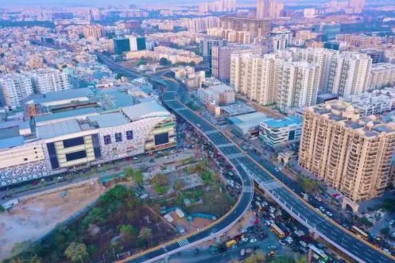
Hyderabad has begun an important transformation with the launch of a high precision survey aimed at modernising roads and improving junctions across the metropolitan region. As the city continues to grow into new districts, the demand on its travel network has become more intense. Residents feel the impact every day through slow traffic, uneven road widths and crowding at intersections. This initiative is designed to capture highly accurate data that will guide the next phase of road engineering. Planners will be able to understand existing issues clearly and create long term solutions that match the city’s rapid development.
For daily commuters, this brings hope for smoother movement, safer paths and more enjoyable travel experiences. Hyderabad is not just fixing current problems. It is preparing for the future by mapping every corridor with care and designing an organised mobility plan that benefits pedestrians, cyclists, public transport users and motorists alike.
HMDA Expansion And The Growing Need For Modern Road Planning:
The Hyderabad Metropolitan Development Authority now governs a vast region that stretches across many districts and hundreds of villages. This expanded responsibility has created an urgent need for careful road planning. Older roads that once served small communities are now used by thousands of vehicles every hour.

As new commercial hubs, residential colonies and educational centres appear, they add more pressure to an already strained network. The high precision survey is meant to introduce a structured approach that covers every stretch of the metropolitan area.
Understanding The High Precision Differential Positioning Survey:
The survey uses advanced Differential Global Positioning methods that provide sub centimetre accuracy. This allows engineers to record every detail of the road network, from corridor width to pedestrian space.
The technology also captures multi satellite data that eliminates errors and helps planners understand long stretches with unmatched clarity. Such precise recordings support meaningful engineering decisions and prevent costly corrections later. This approach is particularly helpful for intersections, narrow roads and mixed traffic areas.
Below are key elements of this survey presented with numbered points:
- Multi satellite signals improve the reliability of data collected.
- Road boundaries can be checked to prevent disputes or encroachments.
- The width of corridors can be analysed for future expansion.
- Utilities and underground structures can be identified before construction.
- Pedestrian space and turning areas can be redesigned accurately.
Role Of Drone Based Mapping And Digital Sketch Plans
Drone mapping plays an important role in the survey by capturing high resolution visuals of long corridors and complex junctions.
To make the role of drones clearer, the points below explain their importance:
- Drones capture complete corridor shapes that are hard to inspect manually.
- They help detect slopes and uneven surfaces.
- Side lanes, service roads and feeder roads are recorded precisely.
- Built structures around the corridor are identified.
- Engineers can compare several design possibilities using drone visuals.
These images help planners understand traffic flow, crowded zones and blind spots. After processing this data, consultants prepare digital sketch plans that include cross sections, contours and alignment details.
This combination of ground data and aerial imagery removes guesswork. It allows engineers to create designs that match the actual conditions rather than theoretical assumptions
Creating Road Development Plans For Long Term City Mobility:
Road Development Plans guide how each corridor should evolve in the coming years. These plans detail how wide the lanes must be, where service roads are required and how to correct older designs that do not match modern needs.
Uniform engineering standards help create a predictable and balanced road network. These plans are especially useful for newly developing outskirts where growth patterns are still shaping. By identifying weak points early and planning wider corridors in advance, the city avoids unnecessary reconstruction later.
The roles of these plans are summarised with numbered points:
- They help finalise realistic and sustainable alignments.
- They define clear right of way limits for future development.
- They ensure consistent lane structure across important corridors.
- They support higher capacity in areas with expected growth.
- They reduce disputes and delays linked to unclear layouts.
Junction Improvement Plans And Their Impact On Daily Commuting:
This subtopic is written in paragraph format only.
Intersections are some of the most challenging parts of a daily commute. They often cause long delays because of poor turning space, unclear signals or confusing lane arrangements. The Junction Improvement Plans created through this survey aim to solve these issues carefully.
Engineers observe how traffic behaves during peak and non peak hours and then prepare designs that reduce conflict points. These plans help create smoother turning pockets, better pedestrian crossings and clearer signal coordination. Improved junctions can ease congestion across full corridors, not just at the crossing point.
This also supports safer movement for school children, elderly pedestrians and cyclists. Over time, better junctions help create a commuting experience that feels more predictable and stress free for everyone.
Field Surveys To Identify Utilities And Structural Gaps:
Ground surveys are essential for understanding what lies beneath and around the roads. These assessments help identify water pipelines, drainage lines, electric poles, telecom cables and other built features.
These field observations are presented clearly with numbered points:
- Property lines are checked to prevent boundary disputes.
- Underground utilities are mapped to avoid accidental damage.
- Existing structures near the road are recorded.
Ground contours and slope patterns are measured. Weak areas that require reinforcement are identified.
They also record slopes, contour changes and property boundaries. Without this information, road upgrades can face sudden delays or damage to essential services. By documenting everything in detail, construction becomes smoother and safer.
Improving Safety For Pedestrians Cyclists And Public Transport Users:
Safety is a major priority of the entire project. As urban roads become busier, vulnerable road users often face greater risks. This survey aims to design wider footpaths, safer crossings and dedicated cycling stretches where possible. It also helps engineers plan smoother merging zones, especially in areas where traffic from side roads joins the main corridor.
The improvements expected from this initiative are listed below:
- Wider and continuous walking paths for pedestrians.
- Clearly marked and safe crossing points.
- Identified zones for cycling in selected corridors.
- Safer merging and turning areas for vehicles.
- Reduced conflict between large and small vehicles.
How This Survey Strengthens Future Mobility Planning?
This subtopic is written in paragraph format only.
Hyderabad is growing into one of the most important urban regions in the country. Its mobility needs are expanding quickly, and this survey provides the foundation for meeting those needs. By observing how people travel, which roads get crowded and which intersections slow down traffic, planners can make informed decisions.
Accurate data helps design corridors that remain relevant for decades. It also helps the city prepare for new housing layouts, business zones and transport systems. Well mapped infrastructure attracts more investment because companies prefer locations with strong and predictable connectivity. This survey is therefore not just about present improvements. It is about setting the direction for Hyderabad’s long term progress.
Conclusion:
The launch of the high precision survey marks a defining moment in Hyderabad’s journey toward organised mobility. By combining satellite data, drone mapping, ground checks and detailed planning, the city is preparing for a future where travel feels easier and more reliable. This initiative promises a safer, smoother and better connected metropolitan region.
FAQs:
The survey helps identify structural gaps, design corrections and long term mobility needs.
Teams use high precision positioning tools and drone mapping to record detailed road information.
They reduce waiting times, streamline turnings and enhance safety for pedestrians and cyclists.
No, the survey includes the entire metropolitan region including distant villages and expanding clusters.
Smaller improvements may appear early, while major upgrades will take more time to be completed.